|
|
German contribution to the Group on Earth Observations and the establishment of the Global Earth Observation System of SystemsGEOSS in brief :: About GEO :: About D-GEO :: European contributions - Copernicus and INSPIRE :: German Contributions :: Documents :: News |
German Contributions |
Documents and Links |
Germany is strongly engaged in European programmes such as Copernicus and carries out an important part of its GEOSS contributions in the context of these European initiatives. On top, Germany participates in all the numerous contributions of the United Nations programmes, conventions and organisations to the GEOSS. Germany further contributes national competencies within the area earth observation and environmental monitoring. There are many and diverse national activities contributing elements contributing to the GEOSS. Among these substantial work is carried out in the framework of Copernicus or EU projects, which are partly co-financed by national institutions. |
|
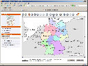
| GeoPortal.De is the main access point to the Geodata Infrastructure Germany (GDI-DE). It is developed and operated by the Federal Agency for Cartography and Geodesy (BKG) under contract of the Inter-ministerial Committee for Geo Information (IMAGI) of the German government. In its architecture and implementation it realizes at a national level today what GEOSS aims for at an international level. Consequently, BKG provides its experience and competence to the design of the GEOSS portal and participates in test implementation programs. |
|
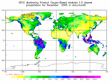
| The Global Precipitation Climatology Centre (GPCC)
under the auspices of the WMO is operated by the German Weather Service (DWD). It supplies global precipitation analyses for climate monitoring and research. This voluntary German contribution to the world climate research program (WCRP) and to the global climate observing system (GCOS) is considered very important also for GEOSS. |
|
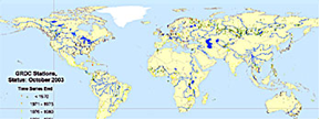
Likewise the Global Runoff Data Center (GRDC) is considered as GEOSS component. It is operated by the Federal Institute of Hydrology on behalf of the WMO and represents an important German contribution to GEOSS. |
|
The World Data Center for Remote Sensing of the Atmosphere (WDC- RSAT) at the German Remote Sensing Data Center (DFD) of DLR makes information on atmospheric trace gases, clouds and land cover, derived from satellite data. As part of the World Data System (WDS) of the International Council for Science (ICSU) it is also a component of GEOSS. |