|
|
German contribution to the Group on Earth Observations and the establishment of the Global Earth Observation System of SystemsGEOSS in brief :: About GEO :: About D-GEO :: European contributions - Copernicus and INSPIRE :: German Contributions :: Documents :: News |
Disaster Management and Early Warning Systems |
Documents and Links |
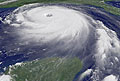
Storms, floods, droughts, earthquakes and connected disasters world-wide cause increasing loss of lives and property. A better organized global monitoring of the system earth, supported by regional and local warning systems that have to be installed, should be able to save human lives and reduce damages to property. |
|
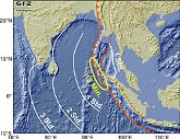
The Tsunami disaster in the Indian Ocean in December 2004 has shown that a functioning early warning system would have save many lives in the affected regions. Therefore substantial efforts are under way world-wide towards establishing comprehensive early warning systems. Germany contributes to these efforts through the German Indonesian Tsunami Early Warning System for the Indian Ocean in particular. |
|
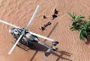
Earth observation is also indispensable for disaster preparedness and post event management. Risk zones can be mapped in preparation for the emergency. After a disaster geo information helps emergency response activities and supports damage mapping. It also contributes to promote structural changes for risk mitigation. The Center for Satellite Based Crisis Information (ZKI) of the DLR provides such emergency mapping services. |